Publications in King
| Title | Publication Year Sort ascending | Abstract | Author | Series | Publisher | |
|---|---|---|---|---|---|---|
|
San Andreas carbonates in the Texas panhandle: sedimentation and diagenesis associated with magnesium-calcium-chloride brines | 1982 | The San Andres evaporitic sequence in the Palo Duro Basin comprises several thick carbonate units in its lower part and many thin units in its upperpart. To the south, across the Northern Shelf of the Midland Basin, evaporites pinch out and carbonates predominate. |
Bein, Amos, Land, L.S. | Report of Investigations | Bureau of Economic Geology |
|
Petroleum potential of the Palo Duro basin, Texas panhandle | 1982 | The Palo Duro Basin seemingly has all the elements necessary for hydrocarbon generation and accumulation: reservoirs, traps, source rocks, and sufficient thermal maturity. Porous facies in pre-Pennsylvanian, Pennsylvanian, and Permian strata are potential hydrocarbon reservoirs. |
Dutton, S.P., Goldstein, A.G., Ruppel, S.C. | Report of Investigations | Bureau of Economic Geology |
|
Impact of evaporite dissolution and collapse on highways and other cultural features in the Texas panhandle and eastern New Mexico | 1981 | Geological investigations in the Texas Panhandle and eastern New Mexico indicate that regional subsurface dissolution of Permian evaporites has occurred and is an ongoing process. |
Simpkins, W.W., Gustavson, T.C., Alhades, A.B., Hoadley, A.D. | Geological Circular | Bureau of Economic Geology |
|
Lower Permian facies of the Palo Duro basin, Texas: depositional systems, shelf-margin evolution, paleogeography, and petroleum potential | 1980 | Lower Permian (Wolfcampian) strata of the Palo Duro Basin consist of thick, terrigenous clastic and carbonate facies that were deposited in (1) fan-delta, (2) high-constructive delta, (3) carbonate shelf and shelf-margin, and (4) slope and basinal systems. |
Handford, C.R., Fredericks, P.E. | Report of Investigations | Bureau of Economic Geology |
|
Depositional systems and hydrocarbon resource potential of the Pennsylvanian system, Palo Duro and Dalhart Basins, Texas panhandle | 1980 | Pennsylvanian clastic and carbonate strata were deposited in a variety of environments within the Palo Duro Basin. Maximum accumulation (totaling 750 m or 2,400 ft) occurred along a northwest-southeast axis. |
Dutton, S.P. | Geological Circular | Bureau of Economic Geology |
|
Petroleum source rock potential and thermal maturity, Palo Duro basin, Texas | 1980 | Samples collected from 20 geographically widespread wells in the sparsely drilled Palo Duro Basin were analyzed for total organic carbon content (TOC). Highest values of TOC, up to 6.9 percent, occur in Upper Permian San Andres dolomite in the southern part of the basin. |
Dutton, S.P. | Geological Circular | Bureau of Economic Geology |
|
Geology and geohydrology of the Palo Duro Basin, Texas panhandle -- a report on the progress of nuclear waste isolation feasibility studies (1978) | 1979 | Integrated, detailed, and comprehensive study of the physical stratigraphy, tectonic history, hydrogeology, geomorphology, and resource potential of the Palo Duro and Dalhart Basins, Texas Panhandle, is part of a national evaluation of ancient salt basins as potential sites for isolation and mana |
Dutton, S.P., Finley, R.J., Galloway, W.E., Gustavson, T.C., Handford, C.R., Presley, M.W. | Geological Circular | Bureau of Economic Geology |
|
Depositional systems, San Angelo Formation (Permian), north Texas -- facies control of red-bed copper mineralization | 1974 | The San Angelo Formation is a mid-Permian sandstone and mudstone sequence about 100 feet thick that crops out in North Texas and dips westward into the Midland Basin; it is composed of two superposed members: the basal Duncan Sandstone Member and the overlying Flowerpot Mudstone Member. |
Smith, G.E. | Report of Investigations | Bureau of Economic Geology |
|
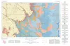
Geologic Atlas of Texas, Lubbock sheet (revised 1993) | 1967 | Geologic map that depicts surface geology of Crosby, Dickens, and King Counties and parts of Hale, Floyd, Motley, Cottle, King, Lubbock, Lynn, Garza, Kent, and Stonewall Counties. The Lubbock Sheet honors the late Dr. |
Eifler, G.K., Frye, J.C., Leonard, A.B., Hentz, T.F., Barnes, V.E. | Geologic Atlas of Texas | Bureau of Economic Geology |
|
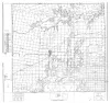
Selected Texas County Maps, 1929-1937 | 1929 | These are 21 Texas county maps made in cooperation with the American Association of Petroleum Geologists and Society of Economic Paleontologists and Mineralogists, issued between 1929 and 1932 and revised in 1937. |
Miscellaneous Map | Bureau of Economic Geology |