Publications in Kent
| Title | Publication Year Sort ascending | Abstract | Author | Series | Publisher | |
|---|---|---|---|---|---|---|

|
Depositional systems and shelf-slope relationships in upper Pennsylvanian rocks, north-central Texas | 1972 | The Eastern Shelf was a constructional platform developed on the margin of the sediment-starved Midland Basin during Late Pennsylvanian and Early Permian time. A mixed terrigenous-carbonate sedimentary province characterized the shelf during most of its history. |
Galloway, W.E., Brown, L.F., Jr. | Report of Investigations | Bureau of Economic Geology |
|
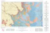
Geologic Atlas of Texas, Lubbock sheet (revised 1993) | 1967 | Geologic map that depicts surface geology of Crosby, Dickens, and King Counties and parts of Hale, Floyd, Motley, Cottle, King, Lubbock, Lynn, Garza, Kent, and Stonewall Counties. The Lubbock Sheet honors the late Dr. |
Eifler, G.K., Frye, J.C., Leonard, A.B., Hentz, T.F., Barnes, V.E. | Geologic Atlas of Texas | Bureau of Economic Geology |
|
Comanchean Stratigraphy of Kent Quadrangle, Trans-Pecos Texas | 1958 | At the northern end of the Coahuila platform, the thinned Comanchean sequence consists of the newly named Sixshooter group of carbonate formations underlain by the newly named Yearwood formation. |
Brand, J.P., DeFord, R.K. | Report of Investigations | Bureau of Economic Geology |

|
Occurrence of Oil and Gas in West Texas | 1957 | Herald, F.A. | UT Publication | ||
|
Geology of the Late Paleozoic Horseshoe Atoll in West Texas | 1956 | Myers, D.A., Stafford, P.T., Burnside, R.J. | UT Publication | ||

|
Boundary of the Pennsylvanian and Permian(?) in the subsurface Scurry reef, Scurry County, Texas | 1952 | Heck, W.A., Yenne, K.A., Henbest, L.G. | Report of Investigations | Bureau of Economic Geology | |

|
Stratigraphic and structural studies in north central Texas | 1929 | Cheney, M.G. | UT Bulletin |