Publications in Johnson
| Title | Publication Year Sort ascending | Abstract | Author | Series | Publisher | |
|---|---|---|---|---|---|---|
|
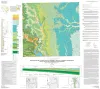
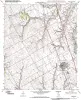
Geologic map of the east part of Cleburne, Texas, 30 x 60 minute quadrangle: South Fort Worth-Interstate 35W corridor | 2011 | Collins, E.W., Baumgardner, R.W., Jr. | Miscellaneous Map | Bureau of Economic Geology | |
|
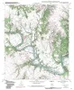
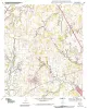
Geologic map of the Brazos Point quadrangle, Texas | 2010 | Collins, E.W. | Open-File Map | Bureau of Economic Geology | |
|
Geologic map of the Keene quadrangle, Texas | 2010 | Collins, E.W. | Open-File Map | Bureau of Economic Geology | |
|
Geologic map of the Blum quadrangle, Texas | 2009 | Collins, E.W. | Open-File Map | Bureau of Economic Geology | |
|
Geologic Map of the Covington quadrangle, Texas | 2009 | Collins, E.W. | Open-File Map | Bureau of Economic Geology | |
|
Geologic map of the Itasca quadrangle, Texas | 2009 | Collins, E.W. | Open-File Map | Bureau of Economic Geology | |
|
Epeiric depositional models for the Lower Cretaceous Washita Group, north-central Texas | 1978 | The Washita Group in North-Central Texas and southeastern Oklahoma consists of up to 114 m of intercalated shale, limestone, and sandstone that accumulated in the shallow, epicontinental sea of the East Texas Basin. |
Scott, R.W., Fee, D., Magee, R., Laali, Hooman | Report of Investigations | Bureau of Economic Geology |
|
Hydrogeologic significance of depositional systems and facies in Lower Cretaceous sandstones, north-central Texas | 1976 | The Lower Cretaceous Hosston and Hensel Sandstones are important sources of ground water in North-Central Texas. |
Hall, W.D. | Geological Circular | Bureau of Economic Geology |
|
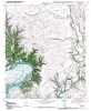
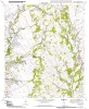
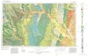
Geologic Atlas of Texas, Dallas sheet (revised 1987) | 1972 | Geologic map that depicts surface geology of Tarrant, Dallas, Kaufman, Ellis, Johnson, Somervell, and Rockwall Counties and parts of Parker, Hood, Erath, Bosque, Hill, Navarro, Henderson, Van Zandt, and Hunt Counties, Texas. |
Barnes, V.E., Shell Oil Co., Humble Oil and Refining Co., Dallas Geological Society, Fort Worth Geological Society, McGowen, J.H., Proctor, C.V., Jr., Haenggi, W.T. | Geologic Atlas of Texas | Bureau of Economic Geology |
|
Lower Cretaceous sands of Texas: stratigraphy and resources | 1967 | Lower Cretaceous sands have long been important aquifers in Central, North-Central, and North Texas. In recent years these sands also have been sources of high-silica industrial or specialty-purpose sand. |
Fisher, W.L., Rodda, P.U. | Report of Investigations | Bureau of Economic Geology |