Publications in Jackson
| Title | Publication Year Sort ascending | Abstract | Author | Series | Publisher | |
|---|---|---|---|---|---|---|
|
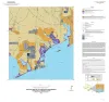
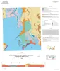
Geologic map of the Turtle Bay quadrangle, Texas Gulf of Mexico coast | 2021 | Paine, J.G., Costard, L. | Open-File Map | Bureau of Economic Geology | |
|
Geologic map of the Bloomington quadrangle, Texas Gulf of Mexico coast | 2020 | Paine, J.G., Costard, L. | Open-File Map | Bureau of Economic Geology | |
|
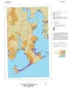
Geologic map of the Olivia and part of the Keller Bay quadrangles, Texas Gulf of Mexico coast | 2020 | Paine, J.G., Costard, L. | Open-File Map | Bureau of Economic Geology | |
|
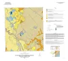
Geologic map of the Kamey quadrangle, Texas Gulf of Mexico Coast | 2018 | Paine, J.G., Collins, E.W., Costard, L. | Open-File Map | Bureau of Economic Geology | |
|
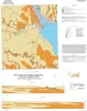
Geologic map of the Point Comfort quadrangle, Texas Gulf of Mexico Coast | 2018 | Paine, J.G., Collins, E.W., Costard, L. | Open-File Map | Bureau of Economic Geology | |
|
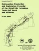
Hydrocarbon production and exploration potential of the distal Frio Formation, Texas Gulf coast and offshore | 1989 | Along the Texas Gulf shoreline and offshore, the distal margin of the Frio Formation is a deep hydrocarbon province that is underexplored relative to the onshore Frio. |
Hamlin, H.S. | Geological Circular | Bureau of Economic Geology |
|
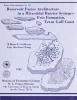
Reservoir facies architecture in a microtidal barrier system -- Frio Formation, Texas Gulf Coast | 1985 | Sandstone reservoirs deposited in microtidal barrier systems contain large oil and gas reserves in several Gulf Coast Basin plays. |
Galloway, W.E., Cheng, E.S. | Report of Investigations | Bureau of Economic Geology |
|
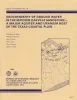
Geochemistry of ground water in the Miocene Oakville Sandstone -- a major aquifer and uranium host of the Texas coastal plain | 1982 | The Oakville Sandstone is a major aquifer and a major host of uranium deposits in the Texas Coastal Plain. |
Henry, C.D., Galloway, W.E., Smith, G.E., Ho, C.L., Morton, J.P., Gluck, J.K. | Report of Investigations | Bureau of Economic Geology |
|
Regional hydrodynamics and hydrochemistry of the uranium-bearing Oakville aquifer (Miocene) of south Texas | 1982 | The Oakville Formation consists of sediments deposited by several major fluvial systems that traversed the Texas Coastal Plain during the Miocene Epoch. |
Smith, G.E., Galloway, W.E., Henry, C.D., Gluck, J.K., McIntyre, J.F., Pisasale, E.T., Spradlin, S.D. | Report of Investigations | Bureau of Economic Geology |
|
Considerations in the extraction of uranium from a fresh-water aquifer -- Miocene Oakville Sandstone, south Texas | 1982 | The Miocene Oakville Sandstone is a major aquifer and uranium host beneath the Texas Coastal Plain. In 1976, approximately 6,000 acre-ft of ground water were withdrawn from the Oakville for municipal use. |
Henry, C.D., Galloway, W.E., Smith, G.E., Childs, C.S., Devine, P.E., Dutton, A.R., Gluck, J.K., McIntyre, J.F. | Report of Investigations | Bureau of Economic Geology |