Publications in Hutchinson
| Title | Publication Year Sort ascending | Abstract | Author | Series | Publisher | |
|---|---|---|---|---|---|---|

|
Coastal evaporite and tidal-flat sediments of the upper Clear Fork and Glorieta Formations, Texas panhandle | 1982 | Red beds, evaporites, and carbonates of the upper Clear Fork and Glorieta Formations (Permian) of the Texas Panhandle form an association of facies deposited in nearshore and supratidal environments along an arid coastline. |
Presley, M.W., McGillis, K.A., Mikan, F.M., Gray, C.A. | Report of Investigations | Bureau of Economic Geology |
|
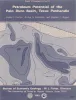
Petroleum potential of the Palo Duro basin, Texas panhandle | 1982 | The Palo Duro Basin seemingly has all the elements necessary for hydrocarbon generation and accumulation: reservoirs, traps, source rocks, and sufficient thermal maturity. Porous facies in pre-Pennsylvanian, Pennsylvanian, and Permian strata are potential hydrocarbon reservoirs. |
Dutton, S.P., Goldstein, A.G., Ruppel, S.C. | Report of Investigations | Bureau of Economic Geology |

|
Regional cross sections of the Texas panhandle: Precambrian to mid-Permian | 1981 | The Texas Panhandle traditionally has been an important source of mineral resources, especially petroleum, and resources will continue to contribute heavily to the economy of the area. The seven cross sections of this report synthesize the subsurface geology of the region. |
Handford, C.R., Dutton, S.P., Fredericks, P.E. | Cross Sections | Bureau of Economic Geology |

|
Middle and Upper Permian salt-bearing strata of the Texas panhandle: lithologic and facies cross sections | 1981 | Regional cross sections of Middle and Upper Permian rocks in the Texas Panhandle illustrate the lithology, depositional systems, and structure of these salt-bearing strata. |
Presley, M.W. | Cross Sections | Bureau of Economic Geology |
|
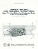
Tansill, Salado, and Alibates Formations: Upper Permian evaporite/carbonate strata of the Texas panhandle | 1981 | The Salado-Tansill and Alibates Formations are the youngest evaporite and carbonate facies within a thick Permian sequence of evaporites, carbonates, and red beds in the Texas Panhandle. |
McGillis, K.A., Presley, M.W. | Geological Circular | Bureau of Economic Geology |

|
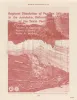
Sand-body geometry and depositional systems, Ogallala Formation, Texas | 1980 | The Neogene Ogallala Formation is an alluvial apron that occurs east of the Rocky Mountains from South Dakota to the Southern High Plains of Texas. The Ogallala was deposited by coalescent, low-gradient, wet alluvial fans that headed in mountains to the west. |
Seni, S.J. | Report of Investigations | Bureau of Economic Geology |
|
Regional dissolution of Permian salt in the Anadarko, Dalhart, and Palo Duro basins of the Texas panhandle | 1980 | A broad zone of salt dissolution that affects parts of the Permian Salado, Seven Rivers, San Andres, Glorieta, and upper Clear Fork Formations occurs beneath the Canadian River Valley from New Mexico eastward toward Amarillo, Texas, and southeastward parallel to the eastern Caprock Escarpment. |
Gustavson, T.C., Finley, R.J., McGillis, K.A. | Report of Investigations | Bureau of Economic Geology |

|
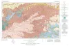
Geologic Atlas of Texas, Perryton sheet (revised 1993) | 1970 | Geologic map that depicts the surface geology of Hansford, Ochiltree, and Lipscomb Counties and parts of Moore, Hutchinson, Roberts, Hemphill, and Sherman Counties. |
Barnes, V.E., Eifler, G.K., Fay, R.O., Quackenbush, W.M., Horn, P.H., Hughes, C.D. | Geologic Atlas of Texas | Bureau of Economic Geology |
|
Geologic Atlas of Texas, Amarillo sheet (reprinted 1981 with limited revisions) | 1969 | Geologic map that depicts the surface geology of Carson, Gray, and Wheeler Counties and parts of Moore, Hutchinson, Roberts, Hemphill, Potter, Randall, Armstrong, Donley, and Collingsworth Counties. |
Eifler, G.K., Phillips Petroleum Co., Humble Oil and Refining Co., Frye, J.C., Leonard, A.B., Knight, G.L., Hughes, C.D., Horn, P.H. | Geologic Atlas of Texas | Bureau of Economic Geology |