Publications in Hemphill
| Title | Publication Year Sort ascending | Abstract | Author | Series | Publisher | |
|---|---|---|---|---|---|---|
|
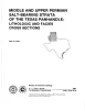
Middle and Upper Permian salt-bearing strata of the Texas panhandle: lithologic and facies cross sections | 1981 | Regional cross sections of Middle and Upper Permian rocks in the Texas Panhandle illustrate the lithology, depositional systems, and structure of these salt-bearing strata. |
Presley, M.W. | Cross Sections | Bureau of Economic Geology |
|
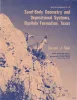
Sand-body geometry and depositional systems, Ogallala Formation, Texas | 1980 | The Neogene Ogallala Formation is an alluvial apron that occurs east of the Rocky Mountains from South Dakota to the Southern High Plains of Texas. The Ogallala was deposited by coalescent, low-gradient, wet alluvial fans that headed in mountains to the west. |
Seni, S.J. | Report of Investigations | Bureau of Economic Geology |
|
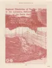
Regional dissolution of Permian salt in the Anadarko, Dalhart, and Palo Duro basins of the Texas panhandle | 1980 | A broad zone of salt dissolution that affects parts of the Permian Salado, Seven Rivers, San Andres, Glorieta, and upper Clear Fork Formations occurs beneath the Canadian River Valley from New Mexico eastward toward Amarillo, Texas, and southeastward parallel to the eastern Caprock Escarpment. |
Gustavson, T.C., Finley, R.J., McGillis, K.A. | Report of Investigations | Bureau of Economic Geology |
|
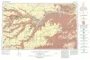
Geologic Atlas of Texas, Perryton sheet (revised 1993) | 1970 | Geologic map that depicts the surface geology of Hansford, Ochiltree, and Lipscomb Counties and parts of Moore, Hutchinson, Roberts, Hemphill, and Sherman Counties. |
Barnes, V.E., Eifler, G.K., Fay, R.O., Quackenbush, W.M., Horn, P.H., Hughes, C.D. | Geologic Atlas of Texas | Bureau of Economic Geology |
|
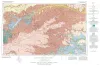
Geologic Atlas of Texas, Amarillo sheet (reprinted 1981 with limited revisions) | 1969 | Geologic map that depicts the surface geology of Carson, Gray, and Wheeler Counties and parts of Moore, Hutchinson, Roberts, Hemphill, Potter, Randall, Armstrong, Donley, and Collingsworth Counties. |
Eifler, G.K., Phillips Petroleum Co., Humble Oil and Refining Co., Frye, J.C., Leonard, A.B., Knight, G.L., Hughes, C.D., Horn, P.H. | Geologic Atlas of Texas | Bureau of Economic Geology |
|
The geology of Hemphill County, Texas | 1932 | Reed, L.C., Longnecker, O.M. | UT Bulletin |