Publications in Garza
| Title | Publication Year Sort ascending | Abstract | Author | Series | Publisher | |
|---|---|---|---|---|---|---|
|
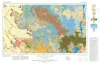
Geologic Atlas of Texas, Big Spring sheet (revised 1994) | 1974 | Geologic map that depicts the surface geology of Borden, Scurry, Fisher, Martin, Howard, Mitchell, and Nolan Counties and parts of Glasscock, Sterling, Coke, Runnels, Taylor, Jones, Dawson, Martin, Lynn, Garza, Kent, and Stonewall Counties. |
Eifler, G.K., Frye, J.C., Leonard, T.F., Barnes, V.E., Trollinger-Gusney and Assoc., Shell Oil Co., Humble Oil and Refining Co., Southern Minerals Corp. | Geologic Atlas of Texas | Bureau of Economic Geology |
|
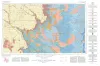
Geologic Atlas of Texas, Lubbock sheet (revised 1993) | 1967 | Geologic map that depicts surface geology of Crosby, Dickens, and King Counties and parts of Hale, Floyd, Motley, Cottle, King, Lubbock, Lynn, Garza, Kent, and Stonewall Counties. The Lubbock Sheet honors the late Dr. |
Eifler, G.K., Frye, J.C., Leonard, A.B., Hentz, T.F., Barnes, V.E. | Geologic Atlas of Texas | Bureau of Economic Geology |

|
Occurrence of Oil and Gas in West Texas | 1957 | Herald, F.A. | UT Publication | ||
|
Geology of the Late Paleozoic Horseshoe Atoll in West Texas | 1956 | Myers, D.A., Stafford, P.T., Burnside, R.J. | UT Publication | ||
|
Subsurface Woodford black shale, West Texas and southeast New Mexico | 1950 | The geographic distribution, lithology, thickness, and paleontology of the subsurface Woodford in the Permian basin are described and illustrated. |
Ellison Jr., S.P. | Report of Investigations | Bureau of Economic Geology |
|
Record of Payne Well in Garza County Texas | 1929 | These circulars issued from the Bureau of Economic Geology contain the record of cores and cuttings from well received and described in the Bureau. |
Well Record |