Publication Search

Publications in Galveston

Title Publication Year Sort ascending Abstract Author Series Publisher
Geologic map of the High Island quadrangle, Texas Gulf of Mexico Coast Geologic map of the High Island quadrangle, Texas Gulf of Mexico Coast 2022 Caudle, T.L., Paine, J.G., Andrews, J.R. Open-File Map Bureau of Economic Geology
Geologic map of the Mud Lake quadrangle, Texas Gulf of Mexico Coast Geologic map of the Mud Lake quadrangle, Texas Gulf of Mexico Coast 2022 Caudle, T.L., Paine, J.G. Open-File Map Bureau of Economic Geology
Geologic map of the Frozen Point and Caplen quadrangles, Texas Gulf of Mexico coast Geologic map of the Frozen Point and Caplen quadrangles, Texas Gulf of Mexico coast 2021 Caudle, T.L., Paine, J.G. Open-File Map Bureau of Economic Geology
Geologic map of the Lake Stephenson and part of the Smith Point quadrangles, Texas Gulf of Mexico coast Geologic map of the Lake Stephenson and part of the Smith Point quadrangles, Texas Gulf of Mexico coast 2020 Caudle, T.L., Paine, J.G. Open-File Map Bureau of Economic Geology
Geologic map of the Flake quadrangle, Texas Gulf of Mexico coast Geologic map of the Flake quadrangle, Texas Gulf of Mexico coast 2019 Caudle, T.L., Paine, J.G. Open-File Map Bureau of Economic Geology
Geoenvironmental map of southwest Bolivar Peninsula, Bolivar and Flake quadrangles, Texas Gulf of Mexico Coast Geoenvironmental map of southwest Bolivar Peninsula, Bolivar and Flake quadrangles, Texas Gulf of Mexico Coast 2007 Tremblay, T.A., White, W.A., Waldinger, R.L., Collins, E.W. Open-File Map Bureau of Economic Geology
Geo-Environmental map of Northeast Galveston Island, Galveston quadrangle, Texas Geo-Environmental map of Northeast Galveston Island, Galveston quadrangle, Texas 2006 Tremblay, T.A., Gibeaut, J.C., Waldinger, R.L., White, W.A., Collins, E.W. Open-File Map Bureau of Economic Geology
Geo-Environmental map of Central Galveston Island, Lake Como quadrangle, Texas Geo-Environmental map of Central Galveston Island, Lake Como quadrangle, Texas 2006 Tremblay, T.A., Gibeaut, J.C., Waldinger, R.L., White, W.A., Collins, E.W. Open-File Map Bureau of Economic Geology
Geo-Environmental map of Southwest Galveston Island, San Luis Pass and Sea Isle quadrangles, Texas Gulf of Mexico Geo-Environmental map of Southwest Galveston Island, San Luis Pass and Sea Isle quadrangles, Texas Gulf of Mexico 2006 Tremblay, T.A., Gibeaut, J.C., Waldinger, R.L., White, W.A., Collins, E.W. Open-File Map Bureau of Economic Geology
Gulf shoreline movement between Sabine Pass and the Brazos River, Texas:  1974 to 1996 Gulf shoreline movement between Sabine Pass and the Brazos River, Texas: 1974 to 1996 1997

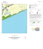
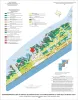
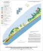
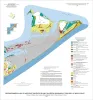
Changes in shoreline position along the southeastern Texas Gulf coast between 1974 and 1996 were documented by conducting a kinematic real-time differential global positioning system (DGPS) field survey in 1996 and comparing that shoreline with other shorelines archived in a geographic informatio

Morton, R.A. Geological Circular Bureau of Economic Geology