Publications in Foard
| Title | Publication Year Sort ascending | Abstract | Author | Series | Publisher | |
|---|---|---|---|---|---|---|
|
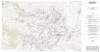
Geologic map of the Seymour aquifer deposits, Vernon, Texas 30x60 minute quadrangle, Texas | 2003 | Collins, E.W. | Open-File Map | Bureau of Economic Geology | |
|
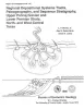
Regional depositional systems tracts, paleogeography, and sequence stratigraphy, Upper Pennsylvanian and Lower Permian strata, north- and west-central Texas | 1990 | Sixteen depositional sequences, commonly called cyclothems, each composed mostly of limestone(retrogradational/transgressive) and siliciclastic (progradational/regressive) subsequences, or systems tracts, record the paleogeography during Late Pennsylvanian (Virgilian Epoch) and Early Permian (Wol |
Brown, L.F., Jr., Solis-Iriarte, R.F., Johns, D.A. | Report of Investigations | Bureau of Economic Geology |
|
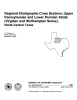
Regional stratigraphic cross sections, Upper Pennsylvanian and Lower Permian strata (Virgilian and Wolfcampian Series), north-central Texas | 1987 | This cross section set comprises 14 dip (E-W) sections and 9 strike (N-S) stratigraphic cross sections (with text), correlating upper Pennsylvanian (Virgilian) and lower Permian (Wolfcampian) strata throughout the subsurface in all or parts of 28 counties of North-Central Texas. |
Brown, L.F., Jr., Solis-Iriarte, R.F., Johns, D.A. | Cross Sections | |
|
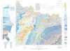
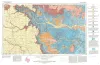
Geologic Atlas of Texas, Wichita Falls-Lawton sheet | 1987 | Geologic map that depicts the surface geology of Hardeman, Wilbarger, Wichita, Clay, Knox, Baylor, Archer, Haskell, Throckmorton, Young, and Foard Counties and part of Jack County, Texas. The 20-page booklet indicates geologic formations, abbreviations, and ages. |
Barnes, V.E., Hentz, T.F., Brown, L.F., Jr., Cleaves, A.W., Kier, R.S., McGowen, J.H., Parrish, W.C., Ramsey, J.W. | Geologic Atlas of Texas | Bureau of Economic Geology |
|
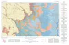
Bouguer gravity Atlas of Texas, Plainview sheet | 1986 | This folded transparent map is at the same scale as its corresponding Geologic Atlas of Texas (GAT) sheet and can be superimposed on it to compare gravity information with surface geology. |
Keller, G.R., Aiken, C.L.V. | Bouguer Gravity Atlas of Texas | Bureau of Economic Geology |
|
Depositional systems, San Angelo Formation (Permian), north Texas -- facies control of red-bed copper mineralization | 1974 | The San Angelo Formation is a mid-Permian sandstone and mudstone sequence about 100 feet thick that crops out in North Texas and dips westward into the Midland Basin; it is composed of two superposed members: the basal Duncan Sandstone Member and the overlying Flowerpot Mudstone Member. |
Smith, G.E. | Report of Investigations | Bureau of Economic Geology |
|
Geologic Atlas of Texas, Plainview sheet (revised 1992) | 1968 | Geologic map that depicts surface geology of Swisher, Briscoe, Hall, and Childress Counties and parts of Randall, Armstrong, Donley, Collingsworth, Hale, Floyd, Motley, and Cottle Counties. |
Barnes, V.E., Humble Oil and Refining Co., Shell Oil Co., Eifler, G.K., Knight, G.L., Hughes, C.D., Horn, P.H., Quackenbush, W.M. | Geologic Atlas of Texas | Bureau of Economic Geology |
|
Geologic Atlas of Texas, Lubbock sheet (revised 1993) | 1967 | Geologic map that depicts surface geology of Crosby, Dickens, and King Counties and parts of Hale, Floyd, Motley, Cottle, King, Lubbock, Lynn, Garza, Kent, and Stonewall Counties. The Lubbock Sheet honors the late Dr. |
Eifler, G.K., Frye, J.C., Leonard, A.B., Hentz, T.F., Barnes, V.E. | Geologic Atlas of Texas | Bureau of Economic Geology |
|
Stratigraphic and structural studies in north central Texas | 1929 | Cheney, M.G. | UT Bulletin | ||
|
Selected Texas County Maps, 1929-1937 | 1929 | These are 21 Texas county maps made in cooperation with the American Association of Petroleum Geologists and Society of Economic Paleontologists and Mineralogists, issued between 1929 and 1932 and revised in 1937. |
Miscellaneous Map | Bureau of Economic Geology |