Publications in Concho
| Title | Publication Year Sort ascending | Abstract | Author | Series | Publisher | |
|---|---|---|---|---|---|---|
|
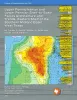
Upper Pennsylvanian and Lower Permian Shelf-to-Basin Facies Architecture and Trends, Eastern Shelf of the Southern Midland Basin, West Texas | 2017 | Our study documents the shelf, shelf-edge, slope, and basin-floor depositional facies characteristics, stratigraphic variations, and sedimentation trends of the Missourian Canyon Group and Virgilian–Wolfcampian Cisco Group across the southern Eastern Shelf and the adjacent Midland Basin. |
Hentz, T.F., Ambrose, W.A., Hamlin, H.S. | Report of Investigations | Bureau of Economic Geology |
|
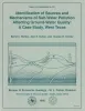
Identification of sources and mechanisms of salt-water pollution affecting ground-water quality: a case study, West Texas | 1990 | Occurrences of ground-water and soil salinization are numerous in the Concho River watershed and its confluence with the Colorado River in West Texas and in other semiarid regions of Texas and the United States. |
Richter, B.C., Dutton, A.R., Kreitler, C.W. | Report of Investigations | Bureau of Economic Geology |
|
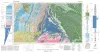
Geologic Atlas of Texas, Brownwood sheet | 1976 | Geologic map that depicts the surface geology of Mills County and parts of Runnels, Coleman, Brown, Comanche, Erath, Hamilton, Coryell, Lampasas, San Saba, McCulloch, Concho, and Menard Counties. The 21-page booklet indicates geologic formations, abbreviations, and ages. |
Kier, R.S., Harwood, P., Brown, L.F., Jr., Goodson, J.L., Barnes, V.E., Shell Oil Co., Humble Oil and Refining Co., Southern Minerals Corp. | Geologic Atlas of Texas | Bureau of Economic Geology |
|
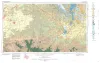
Geologic Atlas of Texas, San Angelo sheet | 1974 | Geologic map that depicts the surface geology of Tom Green, Irion, and Reagan Counties and parts of Midland, Glasscock, Sterling, Coke, Runnels, Concho, Menard, Schleicher, Crockett, and Upton Counties, Texas. |
Barnes, V.E., Eifler, G.K., Shell Oil Co., Southern Minerals Corp., Humble Oil and Refining Co., Cannon, Joe, Brown, W.J., Swartz, G.D. | Geologic Atlas of Texas | Bureau of Economic Geology |
|
Lower Cretaceous sands of Texas: stratigraphy and resources | 1967 | Lower Cretaceous sands have long been important aquifers in Central, North-Central, and North Texas. In recent years these sands also have been sources of high-silica industrial or specialty-purpose sand. |
Fisher, W.L., Rodda, P.U. | Report of Investigations | Bureau of Economic Geology |
|
The Carboniferous Rocks of the Llano Region of Central Texas | 1950 | Plummer, F.B. | UT Publication | ||
|
Stratigraphic and structural studies in north central Texas | 1929 | Cheney, M.G. | UT Bulletin | ||
|
Record of Waring Well in Concho County Texas | 1929 | These circulars issued from the Bureau of Economic Geology contain the record of cores and cuttings from well received and described in the Bureau. |
Well Record | ||
|
Report on the Colorado coal field of Texas | 1917 | Drake, N.F. | UT Bulletin |