Publications in Collingsworth
| Title | Publication Year Sort ascending | Abstract | Author | Series | Publisher | |
|---|---|---|---|---|---|---|
|
Impact of evaporite dissolution and collapse on highways and other cultural features in the Texas panhandle and eastern New Mexico | 1981 | Geological investigations in the Texas Panhandle and eastern New Mexico indicate that regional subsurface dissolution of Permian evaporites has occurred and is an ongoing process. |
Simpkins, W.W., Gustavson, T.C., Alhades, A.B., Hoadley, A.D. | Geological Circular | Bureau of Economic Geology |
|
Lower Permian facies of the Palo Duro basin, Texas: depositional systems, shelf-margin evolution, paleogeography, and petroleum potential | 1980 | Lower Permian (Wolfcampian) strata of the Palo Duro Basin consist of thick, terrigenous clastic and carbonate facies that were deposited in (1) fan-delta, (2) high-constructive delta, (3) carbonate shelf and shelf-margin, and (4) slope and basinal systems. |
Handford, C.R., Fredericks, P.E. | Report of Investigations | Bureau of Economic Geology |

|
Sand-body geometry and depositional systems, Ogallala Formation, Texas | 1980 | The Neogene Ogallala Formation is an alluvial apron that occurs east of the Rocky Mountains from South Dakota to the Southern High Plains of Texas. The Ogallala was deposited by coalescent, low-gradient, wet alluvial fans that headed in mountains to the west. |
Seni, S.J. | Report of Investigations | Bureau of Economic Geology |

|
Geology and geohydrology of the Palo Duro basin, Texas panhandle -- a report on the progress of nuclear waste isolation feasibility studies (1979) | 1980 | Since early 1977, the Bureau of Economic Geology has been evaluating several salt-bearing basins within the State of Texas as part of the national nuclear repository program. |
Gustavson, T.C., Presley, M.W., Handford, C.R., Finley, R.J., Dutton, S.P., Baumgardner, R.W., Jr., McGillis, K.A., Simpkins, W.W. | Geological Circular | Bureau of Economic Geology |
|
Depositional systems and hydrocarbon resource potential of the Pennsylvanian system, Palo Duro and Dalhart Basins, Texas panhandle | 1980 | Pennsylvanian clastic and carbonate strata were deposited in a variety of environments within the Palo Duro Basin. Maximum accumulation (totaling 750 m or 2,400 ft) occurred along a northwest-southeast axis. |
Dutton, S.P. | Geological Circular | Bureau of Economic Geology |

|
Facies patterns and depositional history of a Permian Sabkha complex -- Red Cave Formation, Texas panhandle | 1980 | The Red Cave Formation (Permian, Leonard Series) in the Texas Panhandle consists of cyclic, red-bed clastic and carbonate-evaporite members that reflect deposition in extensive coastal sabkhas. |
Handford, C.R., Fredericks, P.E. | Geological Circular | Bureau of Economic Geology |

|
Petroleum source rock potential and thermal maturity, Palo Duro basin, Texas | 1980 | Samples collected from 20 geographically widespread wells in the sparsely drilled Palo Duro Basin were analyzed for total organic carbon content (TOC). Highest values of TOC, up to 6.9 percent, occur in Upper Permian San Andres dolomite in the southern part of the basin. |
Dutton, S.P. | Geological Circular | Bureau of Economic Geology |
|
Climatic controls on erosion in the rolling plains and along the Caprock Escarpment of the Texas panhandle | 1980 | The climate of the Texas Panhandle is primarily semiarid continental, exhibiting a pronounced peak in precipitation during the months of May through July. |
Finley, R.J., Gustavson, T.C. | Geological Circular | Bureau of Economic Geology |

|
Geology and geohydrology of the Palo Duro Basin, Texas panhandle -- a report on the progress of nuclear waste isolation feasibility studies (1978) | 1979 | Integrated, detailed, and comprehensive study of the physical stratigraphy, tectonic history, hydrogeology, geomorphology, and resource potential of the Palo Duro and Dalhart Basins, Texas Panhandle, is part of a national evaluation of ancient salt basins as potential sites for isolation and mana |
Dutton, S.P., Finley, R.J., Galloway, W.E., Gustavson, T.C., Handford, C.R., Presley, M.W. | Geological Circular | Bureau of Economic Geology |
|
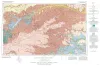
Geologic Atlas of Texas, Amarillo sheet (reprinted 1981 with limited revisions) | 1969 | Geologic map that depicts the surface geology of Carson, Gray, and Wheeler Counties and parts of Moore, Hutchinson, Roberts, Hemphill, Potter, Randall, Armstrong, Donley, and Collingsworth Counties. |
Eifler, G.K., Phillips Petroleum Co., Humble Oil and Refining Co., Frye, J.C., Leonard, A.B., Knight, G.L., Hughes, C.D., Horn, P.H. | Geologic Atlas of Texas | Bureau of Economic Geology |