Publications in Chambers
| Title | Publication Year Sort ascending | Abstract | Author | Series | Publisher | |
|---|---|---|---|---|---|---|
|
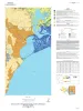
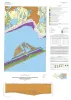
Geologic map of the Cove and Umbrella Point quadrangles, Texas Gulf coast | 2025 | Caudle, T.L., Paine, J.G. | Open-File Map | Bureau of Economic Geology | |
|
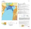
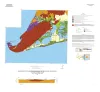
Geologic Map of Trinity Bay, Texas Gulf coast | 2025 | Caudle, T.L., Paine, J.G. | Open-File Map | Bureau of Economic Geology | |
|
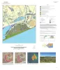
Geologic map of the High Island quadrangle, Texas Gulf of Mexico Coast | 2022 | Caudle, T.L., Paine, J.G., Andrews, J.R. | Open-File Map | Bureau of Economic Geology | |
|
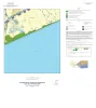
Geologic map of the Mud Lake quadrangle, Texas Gulf of Mexico Coast | 2022 | Caudle, T.L., Paine, J.G. | Open-File Map | Bureau of Economic Geology | |
|
Geologic map of the Frozen Point and Caplen quadrangles, Texas Gulf of Mexico coast | 2021 | Caudle, T.L., Paine, J.G. | Open-File Map | Bureau of Economic Geology | |
|
Geologic map of the Lake Stephenson and part of the Smith Point quadrangles, Texas Gulf of Mexico coast | 2020 | Caudle, T.L., Paine, J.G. | Open-File Map | Bureau of Economic Geology | |
|
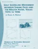
Gulf shoreline movement between Sabine Pass and the Brazos River, Texas: 1974 to 1996 | 1997 | Changes in shoreline position along the southeastern Texas Gulf coast between 1974 and 1996 were documented by conducting a kinematic real-time differential global positioning system (DGPS) field survey in 1996 and comparing that shoreline with other shorelines archived in a geographic informatio |
Morton, R.A. | Geological Circular | Bureau of Economic Geology |
|
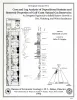
Core and Log Analyses of Depositional Systems and Reservoir Properties ... in Frio, Vicksburg, and Wilcox Sandstones | 1992 | The Gas Research Institute, U.S. Department of Energy, and the State of Texas cooperated in joint-venture research to evaluate the infield reserve growth potential of mature gas fields containing conventional reservoirs. |
Levey, R.A., Grigsby, J.D. | Geological Circular | Bureau of Economic Geology |
|
Shoreline and vegetation-line movement, Texas Gulf coast, 1974 to 1982 | 1989 | The purposes of this study were (1) to quantify recent (1974 to 1982) movement of Texas shorelines and vegetation lines by analysis of aerial photographs; (2) to place this movement in historical (pre-1974) context; and (3) to examine the influence of environmental variables such as storms, sea l |
Paine, J.G., Morton, R.A. | Geological Circular | Bureau of Economic Geology |
|
Hydrocarbon production and exploration potential of the distal Frio Formation, Texas Gulf coast and offshore | 1989 | Along the Texas Gulf shoreline and offshore, the distal margin of the Frio Formation is a deep hydrocarbon province that is underexplored relative to the onshore Frio. |
Hamlin, H.S. | Geological Circular | Bureau of Economic Geology |