Publications in Carson
| Title | Publication Year Sort ascending | Abstract | Author | Series | Publisher | |
|---|---|---|---|---|---|---|
|
Petroleum potential of the Palo Duro basin, Texas panhandle | 1982 | The Palo Duro Basin seemingly has all the elements necessary for hydrocarbon generation and accumulation: reservoirs, traps, source rocks, and sufficient thermal maturity. Porous facies in pre-Pennsylvanian, Pennsylvanian, and Permian strata are potential hydrocarbon reservoirs. |
Dutton, S.P., Goldstein, A.G., Ruppel, S.C. | Report of Investigations | Bureau of Economic Geology |
|
Tansill, Salado, and Alibates Formations: Upper Permian evaporite/carbonate strata of the Texas panhandle | 1981 | The Salado-Tansill and Alibates Formations are the youngest evaporite and carbonate facies within a thick Permian sequence of evaporites, carbonates, and red beds in the Texas Panhandle. |
McGillis, K.A., Presley, M.W. | Geological Circular | Bureau of Economic Geology |
|
Middle and Upper Permian salt-bearing strata of the Texas panhandle: lithologic and facies cross sections | 1981 | Regional cross sections of Middle and Upper Permian rocks in the Texas Panhandle illustrate the lithology, depositional systems, and structure of these salt-bearing strata. |
Presley, M.W. | Cross Sections | Bureau of Economic Geology |
|
Climatic controls on erosion in the rolling plains and along the Caprock Escarpment of the Texas panhandle | 1980 | The climate of the Texas Panhandle is primarily semiarid continental, exhibiting a pronounced peak in precipitation during the months of May through July. |
Finley, R.J., Gustavson, T.C. | Geological Circular | Bureau of Economic Geology |
|
Lower Permian facies of the Palo Duro basin, Texas: depositional systems, shelf-margin evolution, paleogeography, and petroleum potential | 1980 | Lower Permian (Wolfcampian) strata of the Palo Duro Basin consist of thick, terrigenous clastic and carbonate facies that were deposited in (1) fan-delta, (2) high-constructive delta, (3) carbonate shelf and shelf-margin, and (4) slope and basinal systems. |
Handford, C.R., Fredericks, P.E. | Report of Investigations | Bureau of Economic Geology |
|
Sand-body geometry and depositional systems, Ogallala Formation, Texas | 1980 | The Neogene Ogallala Formation is an alluvial apron that occurs east of the Rocky Mountains from South Dakota to the Southern High Plains of Texas. The Ogallala was deposited by coalescent, low-gradient, wet alluvial fans that headed in mountains to the west. |
Seni, S.J. | Report of Investigations | Bureau of Economic Geology |
|
Regional dissolution of Permian salt in the Anadarko, Dalhart, and Palo Duro basins of the Texas panhandle | 1980 | A broad zone of salt dissolution that affects parts of the Permian Salado, Seven Rivers, San Andres, Glorieta, and upper Clear Fork Formations occurs beneath the Canadian River Valley from New Mexico eastward toward Amarillo, Texas, and southeastward parallel to the eastern Caprock Escarpment. |
Gustavson, T.C., Finley, R.J., McGillis, K.A. | Report of Investigations | Bureau of Economic Geology |
|
Petroleum source rock potential and thermal maturity, Palo Duro basin, Texas | 1980 | Samples collected from 20 geographically widespread wells in the sparsely drilled Palo Duro Basin were analyzed for total organic carbon content (TOC). Highest values of TOC, up to 6.9 percent, occur in Upper Permian San Andres dolomite in the southern part of the basin. |
Dutton, S.P. | Geological Circular | Bureau of Economic Geology |
|
Geology and geohydrology of the Palo Duro Basin, Texas panhandle -- a report on the progress of nuclear waste isolation feasibility studies (1978) | 1979 | Integrated, detailed, and comprehensive study of the physical stratigraphy, tectonic history, hydrogeology, geomorphology, and resource potential of the Palo Duro and Dalhart Basins, Texas Panhandle, is part of a national evaluation of ancient salt basins as potential sites for isolation and mana |
Dutton, S.P., Finley, R.J., Galloway, W.E., Gustavson, T.C., Handford, C.R., Presley, M.W. | Geological Circular | Bureau of Economic Geology |
|
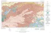
Geologic Atlas of Texas, Amarillo sheet (reprinted 1981 with limited revisions) | 1969 | Geologic map that depicts the surface geology of Carson, Gray, and Wheeler Counties and parts of Moore, Hutchinson, Roberts, Hemphill, Potter, Randall, Armstrong, Donley, and Collingsworth Counties. |
Eifler, G.K., Phillips Petroleum Co., Humble Oil and Refining Co., Frye, J.C., Leonard, A.B., Knight, G.L., Hughes, C.D., Horn, P.H. | Geologic Atlas of Texas | Bureau of Economic Geology |