Publications in Armstrong
| Title | Publication Year Sort ascending | Abstract | Author | Series | Publisher | |
|---|---|---|---|---|---|---|

|
Geology and geohydrology of the Palo Duro basin, Texas panhandle -- a report on the progress of nuclear waste isolation feasibility studies (1979) | 1980 | Since early 1977, the Bureau of Economic Geology has been evaluating several salt-bearing basins within the State of Texas as part of the national nuclear repository program. |
Gustavson, T.C., Presley, M.W., Handford, C.R., Finley, R.J., Dutton, S.P., Baumgardner, R.W., Jr., McGillis, K.A., Simpkins, W.W. | Geological Circular | Bureau of Economic Geology |

|
Petroleum source rock potential and thermal maturity, Palo Duro basin, Texas | 1980 | Samples collected from 20 geographically widespread wells in the sparsely drilled Palo Duro Basin were analyzed for total organic carbon content (TOC). Highest values of TOC, up to 6.9 percent, occur in Upper Permian San Andres dolomite in the southern part of the basin. |
Dutton, S.P. | Geological Circular | Bureau of Economic Geology |
|
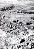
Climatic controls on erosion in the rolling plains and along the Caprock Escarpment of the Texas panhandle | 1980 | The climate of the Texas Panhandle is primarily semiarid continental, exhibiting a pronounced peak in precipitation during the months of May through July. |
Finley, R.J., Gustavson, T.C. | Geological Circular | Bureau of Economic Geology |

|
Geology and geohydrology of the Palo Duro Basin, Texas panhandle -- a report on the progress of nuclear waste isolation feasibility studies (1978) | 1979 | Integrated, detailed, and comprehensive study of the physical stratigraphy, tectonic history, hydrogeology, geomorphology, and resource potential of the Palo Duro and Dalhart Basins, Texas Panhandle, is part of a national evaluation of ancient salt basins as potential sites for isolation and mana |
Dutton, S.P., Finley, R.J., Galloway, W.E., Gustavson, T.C., Handford, C.R., Presley, M.W. | Geological Circular | Bureau of Economic Geology |
|
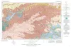
Geologic Atlas of Texas, Amarillo sheet (reprinted 1981 with limited revisions) | 1969 | Geologic map that depicts the surface geology of Carson, Gray, and Wheeler Counties and parts of Moore, Hutchinson, Roberts, Hemphill, Potter, Randall, Armstrong, Donley, and Collingsworth Counties. |
Eifler, G.K., Phillips Petroleum Co., Humble Oil and Refining Co., Frye, J.C., Leonard, A.B., Knight, G.L., Hughes, C.D., Horn, P.H. | Geologic Atlas of Texas | Bureau of Economic Geology |
|
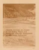
The geologic story of Palo Duro Canyon | 1969 | Like the early Spanish explorers who first saw Palo Duro Canyon, today's visitor is likely to view the impressive canyon with surprise and awe. |
Guidebook | Bureau of Economic Geology | |

|
Geologic Atlas of Texas, Plainview sheet (revised 1992) | 1968 | Geologic map that depicts surface geology of Swisher, Briscoe, Hall, and Childress Counties and parts of Randall, Armstrong, Donley, Collingsworth, Hale, Floyd, Motley, and Cottle Counties. |
Barnes, V.E., Humble Oil and Refining Co., Shell Oil Co., Eifler, G.K., Knight, G.L., Hughes, C.D., Horn, P.H., Quackenbush, W.M. | Geologic Atlas of Texas | Bureau of Economic Geology |