
The Van Horn Sandstone in southwestern Culberson and southeastern Hudspeth counties, Texas, was studied in cooperation with the U.S.
The Woodbine Formation is composed largely of terrigenous sediment eroded from Paleozoic sedimentary and weakly metamorphosed sedimentary rocks of the Ouachita Mountains in southern Oklahoma and Arkansas and subsequently deposited in a complex of nearshore environments along the margins of the broadly subsiding Northeast Texas Basin. Three principal depositional systems are recognized in Woodbine rocks--a fluvial system, a high-destructive delta system, and a shelf-strandplain system.
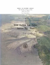
A study of Gum Hollow delta, a modern fan delta along the north shore of Nueces Bay, Texas, was undertaken to determine the mechanics of fan development and the relationships between sedimentary processes and structures. In addition this study provides criteria that can be utilized in recognizing ancient fan delta deposits and in making a distinction between ancient fan and bayhead deltas. Further, the study documents changes in form of the fan and relates these changes to specific geologic processes.
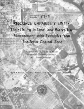
A resource capability unit is an environmental entity--land, water, area of active process, or biota--defined in terms of the nature, degree of activity, or use it can sustain without losing an acceptable level of environmental quality. Units are established by recognizing elements of first-order environmental significance, whether dominantly physical, biologic, or chemical.
Tertiary rocks, including sandstone, conglomerate, shale, pyroclastics, tuff, and lava, are preserved in Big Bend National Park and in a much larger area to the west and northwest. Some of the rocks have distinctive characteristics that enable recognition by their lithology. Others are distinctly dissimilar, although they may have been deposited about the same time.