Cain City Quadrangle Publications
| Title | Publication Year Sort ascending | Abstract | Author | Series | Publisher | |
|---|---|---|---|---|---|---|
|
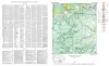
Geologic map of the Cain City quadrangle, Gillespie and Kendall Counties, Texas | 1952 | Cain City quadrangle is south of the Llano region and is in the marginal portion of the Edwards Plateau where much of the plateau surface has been destroyed by erosion. Northeastward-trending lobes and outliers of the Edwards Plateau are present in the southern part. |
Barnes, V.E. | Geologic Quadrangle Map | Bureau of Economic Geology |