Brazos River Publications
| Title | Publication Year Sort ascending | Abstract | Author | Series | Publisher | |
|---|---|---|---|---|---|---|
|
Gulf of Mexico Shoreline Change, Brazos River to San Luis Pass, Texas | 2021 | Caudle, T.L., Paine, J.G., Andrews, J.R., Suarez, J.R. | Posters | ||
| |
Gulf of Mexico Shoreline Change, Eastern Matagorda Peninsula, Texas: Colorado River to Brazos River | 2021 | Caudle, T.L., Paine, J.G., Andrews, J.R., Suarez, J.R. | Posters | ||
|
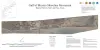
Gulf shoreline movement between Sabine Pass and the Brazos River, Texas: 1974 to 1996 | 1997 | Changes in shoreline position along the southeastern Texas Gulf coast between 1974 and 1996 were documented by conducting a kinematic real-time differential global positioning system (DGPS) field survey in 1996 and comparing that shoreline with other shorelines archived in a geographic informatio |
Morton, R.A. | Geological Circular | Bureau of Economic Geology |
|
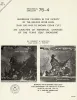
Shoreline changes in the vicinity of Brazos River delta (San Luis Pass to Brown Cedar Cut) -- an analysis of historical changes of the Texas Gulf shoreline | 1975 | Historical monitoring in the vicinity of the Brazos River delta (San Luis Pass to Brown Cedar Cut) records the nature and magnitude of changes in position of the shoreline 'and vegetation line and provides insight into the factors affecting those changes. |
Morton, R.A., Pieper, M.J. | Geological Circular | Bureau of Economic Geology |
|
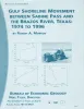
Recent sediments of southeast Texas -- a field guide to the Brazos alluvial and deltaic plains and the Galveston barrier island complex | 1970 | This guidebook is a reprinting of a field guide prepared by Shell Development Company as part of a three-day industrial short course for full-time college teachers in geology, conducted from March 30 to April 1, 1970, by Shell Development Company, Houston, Texas, in cooperation with AGI Council o |
Bernard, H.A., Major, C.F., Parrott, B.S., LeBlanc, R.J. | Guidebook | Bureau of Economic Geology |
|
A stratigraphic datum, Cisco Group (Upper Pennsylvanian), Brazos and Trinity valleys, north-central Texas | 1962 | The Blach Ranch and Breckenridge limestone members of the Thrifty formation are the most persistent mappable rock units in the Cisco group of the Brazos and Trinity River valleys. |
Brown, L.F., Jr. | Report of Investigations | Bureau of Economic Geology |
|
The lower Claiborne on the Brazos River, Texas | 1931 | Renick, B.C., Stenzel, H.B. | UT Bulletin |