Publication Details
Geolocation:
Get the Publication
$15.00
Abstract/Description:
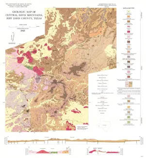
The Davis Mountains are an erosional remnant of a volcanic field that probably covered 5 to 10 times their present areal extent of approximately 2,000 square miles. Many previous workers believed that much of the extrusive material in nearby parts of western Trans-Pecos Texas was erupted from the central Davis Mountains (Colton, 1957, p. 76; Lewis, 1949, p. 89; McAnulty, 1955, p. 54<3; Zabriskie, 1951, p. 36). To test this idea, petrologic, stratigraphic, and structural investigations were made in order to understand the relationships among the various extrusive and intrusive rocks in the central Davis Mountains. The Davis Mountains are located in Jeff Davis, Presidio, and Brewster counties in Trans-Pecos Texas; this report deals with about 24$0 square miles in the highest part of the range. Fort Davis is approximately 10 miles east of the southern part of the map area, and Marfa is about 18 miles south of the area. Ready access is provided by State Highways 166 and 118, Spur 78, several graded county roads, and numerous unimproved ranch roads. The Davis Mountains lie on the southeast end of the Diablo Platform of Permian age (King, 194,2, p. 665-666). The Diablo Platform is bounded on the northeast by the Delaware basin, and on the southwest by the Marfa basin. The central Davis Mountains consist of a series of sodarich, silicic pyroclastic units and lava flows of late Eocene to Oligocene age. The volcanic rocks were intruded by stocks, sills, and dikes, mostly in the same compositional range, during the latter part of the period of eruptive activity. Thirteen volcanic units, with an aggregate thickness of approximately 2,500 feet, and six intrusive units were mapped.