Publications in Sterling
| Title | Publication Year Sort ascending | Abstract | Author | Series | Publisher | |
|---|---|---|---|---|---|---|
|
Upper Pennsylvanian and Lower Permian Shelf-to-Basin Facies Architecture and Trends, Eastern Shelf of the Southern Midland Basin, West Texas | 2017 | Our study documents the shelf, shelf-edge, slope, and basin-floor depositional facies characteristics, stratigraphic variations, and sedimentation trends of the Missourian Canyon Group and Virgilian–Wolfcampian Cisco Group across the southern Eastern Shelf and the adjacent Midland Basin. |
Hentz, T.F., Ambrose, W.A., Hamlin, H.S. | Report of Investigations | Bureau of Economic Geology |
|
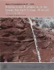
Stratigraphic analysis of the Upper Devonian Woodford Formation, Permian Basin, West Texas and southeastern New Mexico | 1991 | The Upper Devonian Woodford Formation is an organic-rich petroleum source rock that extends throughout West Texas and southeastern New Mexico and currently is generating oil or gas in the subsurface. |
Comer, J.B. | Report of Investigations | Bureau of Economic Geology |

|
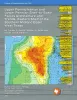
Hydrogeology and hydrochemistry of the Ogallala aquifer, southern High Plains, Texas panhandle and eastern New Mexico | 1988 | The Ogallala aquifer, which underlies the Southern High Plains, consists of the saturated sediments of the Neogene Ogallala Formation. The aquifer is the main source of water for the High Plains of Texas and New Mexico and is being severely depleted by extensive pumpage for irrigation. |
Nativ, Ronit | Report of Investigations | Bureau of Economic Geology |
|
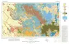
Bouguer gravity Atlas of Texas, Big Spring sheet | 1986 | This folded transparent map is at the same scale as its corresponding Geologic Atlas of Texas (GAT) sheet and can be superimposed on it to compare gravity information with surface geology. |
Keller, G.R., Aiken, C.L.V. | Bouguer Gravity Atlas of Texas | Bureau of Economic Geology |
|
Depositional framework of the Lower Dockum Group (Triassic), Texas panhandle | 1979 | The Upper Triassic Dockum Group of Texas and New Mexico is composed of 200 to 2,000 feet of complexly interrelated terrigenous clastic facies ranging from mudstone to conglomerate. |
McGowen, J.H., Granata, G.E., Seni, S.J. | Report of Investigations | Bureau of Economic Geology |
|
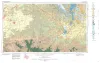
Geologic Atlas of Texas, Big Spring sheet (revised 1994) | 1974 | Geologic map that depicts the surface geology of Borden, Scurry, Fisher, Martin, Howard, Mitchell, and Nolan Counties and parts of Glasscock, Sterling, Coke, Runnels, Taylor, Jones, Dawson, Martin, Lynn, Garza, Kent, and Stonewall Counties. |
Eifler, G.K., Frye, J.C., Leonard, T.F., Barnes, V.E., Trollinger-Gusney and Assoc., Shell Oil Co., Humble Oil and Refining Co., Southern Minerals Corp. | Geologic Atlas of Texas | Bureau of Economic Geology |
|
Geologic Atlas of Texas, San Angelo sheet | 1974 | Geologic map that depicts the surface geology of Tom Green, Irion, and Reagan Counties and parts of Midland, Glasscock, Sterling, Coke, Runnels, Concho, Menard, Schleicher, Crockett, and Upton Counties, Texas. |
Barnes, V.E., Eifler, G.K., Shell Oil Co., Southern Minerals Corp., Humble Oil and Refining Co., Cannon, Joe, Brown, W.J., Swartz, G.D. | Geologic Atlas of Texas | Bureau of Economic Geology |
|
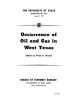
Occurrence of Oil and Gas in West Texas | 1957 | Herald, F.A. | UT Publication | ||
|
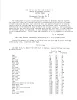
The Texas Elkhorn Syndicate's Richardson No. 1 in Sterling County Texas | 1929 | These circulars issued from the Bureau of Economic Geology contain the record of cores and cuttings from well received and described in the Bureau. |
Well Record |