Miscellaneous Maps, Charts & Sections
-
Books & Reports
- Reports of Investigations
- Guidebooks
- Udden Series
- Geological Circulars
- Down To Earth
- Atlases of Major Oil and Gas Reservoirs
- Texas Memorial Museum Publications
- Environmental Geologic Atlas of the Texas Coastal Zone
- Mineral Resource Circulars
- Other Reports
- Seminars and Workshops
- Handbooks
- Submerged Lands of Texas
- Symposia
- Annual Reports
- Open File Reports
-
Maps & Cross Sections
- Thematic Maps
- Miscellaneous Maps, Charts & Sections
- Geologic Atlas of Texas
- STATEMAP Project Maps
- Geologic Quadrangle Maps
- Cross Sections
- Highway Geology Map
- Energy and Mineral Resource Maps
- Shoreline Change and Other Posters
- Wilcox Group, East Texas, Geological / Hydrological Folios
- Bouguer Gravity Atlas of Texas
- River Basin Regional Studies
- Featured Maps
- Posters
- Teachers & the Public
-
Geological Society Publications
- Gulf Coast Association of Geological Societies
- Alabama Geological Society
- Austin Geological Society
- Corpus Christi Geological Society
- Houston Geological Society
- Lafayette Geological Society
- Mississippi Geological Society
- New Orleans Geological Society
- South Texas Geological Society
- GCS SEPM Publications
- Historic BEG & UT Series
 - Downloadable PDF")
 - Downloadable PDF")
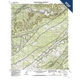
Hunter (Comal and Hays Counties). Digital Download
MM0016-I-D
Hunter (Comal and Hays Counties). Digital Version.
MM0016-I-D. Hunter (Comal and Hays Counties). Geologic map, geology compiled by F. L. Whitney, drafted by D. B. Phillips, edited by Keith Young. Map scale 1 inch = 1 mile. Issued by the Geology Foundation, University of Texas-Austin. 1956. MM0016-I-D, $5.00. Downloadable PDF.
To purchase this map in paper format, please order MM0016-I ($5.00).
For additional maps in this series, please see MM0016.
Keywords: maps, geologic maps, Hunter area, Texas, Comal County, Hays County